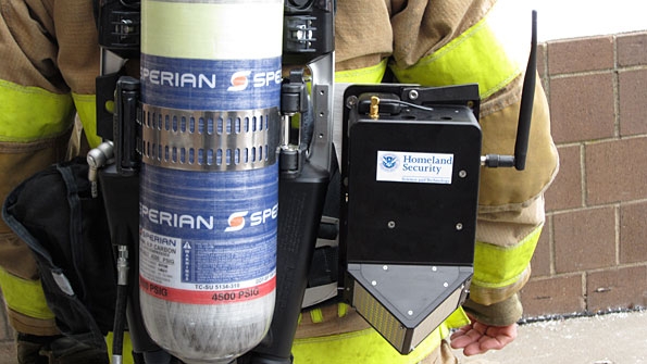
A prototype SCBA-mounted GLANSER unit. Commercial units are expected to be smaller. / Photo courtesy DHS
Because of the inherent danger and physical demands, firefighting is a high-anxiety occupation. Every second counts as firefighters work frantically to minimize damage to property and more important preserve the well-being of those living in the immediate area.
But sometimes firefighters and other first responders encounter situations in which they need to be saved as much as the occupants of a burning building, after becoming disoriented or lost. Typical protocol calls for firefighters to have a partner with them at all times, but these partners can get separated, according to Charles Werner, fire chief for the city of Charlottesville, Va.
The problem could be the result of a structural issue for example, the collapse of a wall, floor or ceiling a physical injury or other unwanted circumstances that cause a firefighter to lose his bearings. Whatever the reason, the realization is terrifying both for the distressed firefighter and everyone else at the scene, Werner said.
"When you get into zero visibility, and you get disoriented, it's probably one of the scariest feelings you'll ever have," Werner said, noting that he was in such a precarious scenario once during his career. "You're in an intolerable environment it's literally unsurvivable without protection, but you only have a limited amount of air, and depending on how hot it is, you can only stand the heat so long.
"And, when you're a fire chief, it's your worst nightmare you realize that you only have minutes in a lot of cases to actually save the firefighter who is lost. It takes everything that you've got and everybody that's on the scene to make that happen."
To date, there is little technology in the field that is able to help. Emergency buttons on LMR radios can alert everyone on the scene that there is a "man down," but the distressed firefighter typically must be within earshot of another crew member or needs to be able to describe his location to an incident commander, who can deploy a Rapid Intervention Team (RIT) to find the firefighter.
However, a disoriented or unconscious firefighter can provide little information, meaning the RIT members are left to play a guessing game in cloud of thick, acrid smoke that normally starts at the last known position of the downed firefighter. GPS has become an increasingly common feature on LMR radios, but the technology usually does not work inside a building, where a satellite does not have a clear path to the radio. In addition, GPS only provides longitude and latitude (X and Y) coordinates; one of the biggest location challenges is determining which floor the firefighter is on in a multi-story building, i.e.,the user's altitude (Z coordinate).
Recently, the U.S. Department of Homeland Security's directorate of science and technology (DHS S&T) has invested considerable resources to develop a viable solution to this life-and-death quandary. After years of work, officials are hopeful they have found the answer with the Geospatial Location Accountability and Navigation System for Emergency Responders (GLANSER) technology, which is designed to provide three-dimensional location data for firefighters without interfering with their normal operations.
SIDEBAR: How GLANSER works
If tested and commercialized successfully, the technology could be a popular tool in the firefighting community, because it addresses a longtime problem, Werner said.
"That's probably the fire chief's worst nightmare to have a lost firefighter and not know where he or she is," he said. "To be able to resolve that issue and rescue a firefighter probably would be one of if not the most important technologies that we'll put in place.
Path to a solution
Aside from fundamental partnering and search-and-rescue techniques, incident commanders have had few options to find firefighters that are lost or disoriented, according to Jalal Mapar, program manager for DHS S&T.
"They have had no ability to track firefighters. There has been nothing no products. Everything that works has worked outside a building with commercial GPS.
"All of these incident commanders have been operating in the dark, as far as where these guys are located inside the building. They just go entirely by radio calls."
The first technology developed by DHS S&T was the "bread crumb" approach, which called for firefighters to place small radio nodes along their path inside a building, with the nodes forming an ad-hoc mesh network that was designed to create a radio trail that would help determine location.
But this approach has many drawbacks, the biggest of which revolved around the fact that firefighters wanted to focus their energies on fighting a fire, not on establishing communications when arriving at a scene, according to Mapar.
"They really don't have time," he said. "[Firefighters] told us that they really don't want to be bothered with spending their time trying to set up base-station relays, drop bread crumbs and then make sure they're working.
"They said, 'All I want to do is have a unit that, when I turn it on, transmits my location back to the incident commander. I don't have time to wait two minutes to boot it, etc. It has to work on its own.'"
3D is the key
In addition to these requirements, firefighters asked DHS S&T to develop a solution that could be implemented at a scene without the help of engineers and would meet intrinsic-safety standards, Mapar said. By leveraging myriad sensor technologies (see sidebar) many of which came from the aerospace industry to guide planes and missiles DHS worked with Honeywell to develop GLANSER, which features units attached to a firefighter's self-contained breathing apparatus (SCBA) that operate on 900 MHz unlicensed spectrum.
With GLANSER, incident commanders are able to see a three-dimensional map that indicates the route each firefighter is taking inside a building (see photo) and includes an altitude reference point. The location information is designed to be accurate within 3 meters, which is about the height of a normal floor in a multi-story building. The graphical interface does not state what floor a firefighter is on, but it does indicate whether a firefighter has gone up or down stairs relative to the point at which he entered the building.
"That ability to get that third-dimensional view of the building is truly the difference maker in this technology," said John Sullivan, deputy chief of the Worchester, Mass., fire department, which participated in a demonstration of GLANSER this summer.
Another key feature of GLANSER is that it did not interfere with normal firefighter operations and did not require any engineers to operate � something Worchester fire officials mandated for the demonstration, according to Mapar. The only DHS S&T personnel allowed on the site were in the incident-command area to answer questions about features and capabilities, he said.
Sullivan was impressed with the demonstration.
"It worked very well. The GLANSER technology is right where we expected it to be. The advancements in the communication pieces and the ability to track on that third dimension have truly advanced a long way, to the point where we're pretty confident in the technology and being able to use it.
"As you know, in the fire service, having confidence in the technology is huge."
Expected to be commercially available next year, the GLANSER system may not be limited to just locating firefighters and other first responders, Mapar said.
"In addition to that, the unit is set up to establish a wireless mesh network all on its own as soon as the unit is turned on, it starts to communicate with the other units around it," he said. "So, when people go into a building, each person becomes a node and, in our case, the more the merrier."
The existence of that mesh network creates multiple communications possibilities for the future, including the potential exchange of data and voice information with additional enhancements, Mapar said.
One potential concern associated with GLANSER is its price, which currently is estimated to be about $3,000 per system a steep figure for budget-strapped fire departments struggling to avoid layoffs. Mapar said that he hopes to convince manufacturers to build systems with GLANSER technology that are leased on a monthly basis, to help lessen the upfront sticker shock associated with an outright purchase.
An even more promising possibility is the chance that the GLANSER technology could be implemented in commercial devices such as smartphones and tablets, which would greatly increase the economies of scale for the components, which traditionally reduces their costs dramatically.
"We started with trying to help the firefighters," Mapar said. "But the technology we're developing is, all of a sudden, catching the eye of the commercial market.
"Some of the big names in the commercial market are watching how we go about putting this out, because they want to use some of the technologies we have developed. They're even thinking about providing it as a service in the location-based services area that promises to be a $5 billion-$10 billion market in the next five years."
Mapar is comfortable with such "unintended consequences" becoming reality, especially if they benefit public safety by reducing GLANSER costs and the location-based technology is used to better locate mobile 911 callers.
Meanwhile, the fact that solutions such as GLANSER are being developed for firefighting a sector often ignored in previous mission-critical communications evolutions is a welcome sign, Werner said.
"I think these newer developments that are coming out are very exciting," he said. "I think we're starting to see that people are taking our challenges. They tried, and they failed, and they tried and they failed. Now, they're starting to get some solutions that really are starting to fit into what we need."
Donny Jackson | Urgent Communications
| 


